Foil: Your right to Know.

Prepared by Mike Carey and Mike Parietti
The Rockland County Legislature has been shamefully gerrymandered, for more than twenty years, at the expense of communities of color in eastern Ramapo, as well as suburban areas and Orthodox communities in western Ramapo. This injustice has been going on for far too long.
So, it is important to know that the process of redistricting the county legislature based on the 2020 Census is currently underway. The Redistricting Committee is expected to release its proposed map for the new district boundaries sometime in the next few weeks and are currently accepting public input.
To be proactive we have published our own proposed map for the new Rockland County Legislature, in cooperation with others, and submitted it to the Redistricting Committee. The map is comprehensive and covers the entire county. All of our proposed districts meet the established state criteria for total population, contiguity and compactness.
However, the most remarkable aspect of our map is that it gives every single community of interest in Rockland a fair share of representation, while respecting the vast majority of municipal boundaries at the village and hamlet level.
State redistricting guidelines direct that communities of interest should be united whenever possible. Our map proves that it is abundantly possible, in fact it is easy, to accommodate all communities of interest with their appropriate portion of political power.
Rather than deliberately and unnecessarily pitting starkly different communities of interest against each other, by mashing them together within the same districts, we have provided each community in the county with an equitable share of districts. This will: 1) act to reduce ethnic, racial, and cultural tensions by giving all groups a place at the table 2) encourage political competition and participation within each respective legislative district, and 3) promote understanding between different communities as they will have no choice but to hear each other out and work together in the legislature to solve the urgent issues we face. This is how true democracy works.
A district-by-district description of our map follows below. It is lengthy and indepth by necessity. When it comes to the drawing of political subdivisions the devil is truly in the details. However, before we launch into that analysis let’s first highlight a few points that will be of particular interest to our readers in Ramapo.
Our map calls for:
If you agree with our proposed map or any aspect of it, please submit a comment of support to the Redistricting Committee legclerk@co.rockland.ny.us Now is the time to make your voice heard.
A comprehensive discussion of our proposed map begins below.
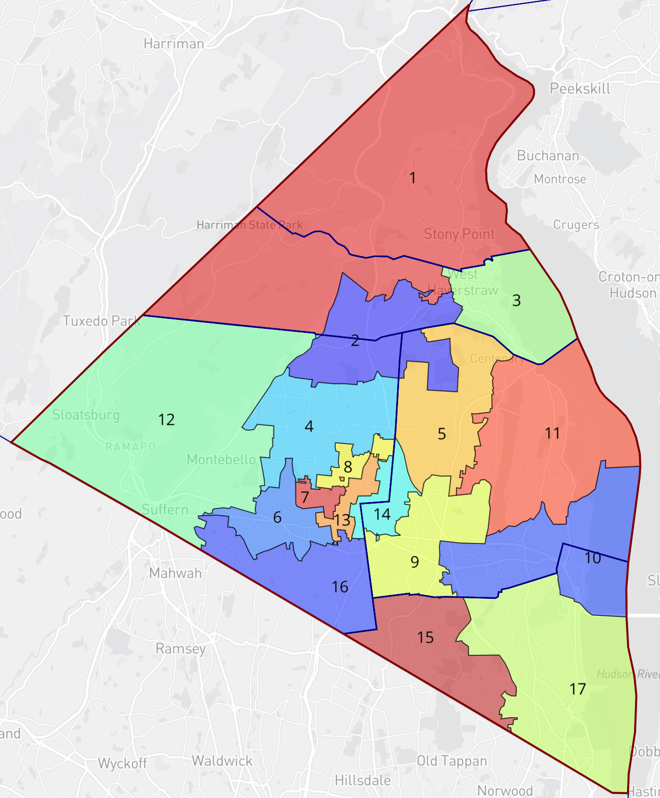
The map is an approximation of how the boundaries should be drawn to create compact contiguous districts that will meet the population variance set by New York State, but also ensure that all communities of interest have a fair share of representation. The present 2010 map is shown on the left below and our proposed new 2020 map is on the right.
To create our map, we used an online mapping tool called ‘Dave’s Redistricting’. The data readily available in that tool was at the Census Track level, which were the building blocks we used to create our proposed legislative districts. However, there is another level of data known as the Census Block. Census Blocks are smaller geographical and population units than Census Tracts and thus can be arranged more nimbly and precisely to form legislative districts. We are currently working on getting access to the Census Block data and we hope to create an even more precise version of our map shortly.
First a note about a couple of districts.
If you look closely, there is an island of geography within District # 8 that is the color of the neighboring District # 13. This was caused by a quirk in one of the Census Tracts, that made it impossible to separate that isolated island, from a much large Census Tract that is part of District 13. However, this kind of anomaly can be easily corrected with the Census Block data.
Also, you can see that the northeast corner of District 8 is only technically contiguous to the remainder of District 8 as it is connected at a single point. This is not unlike the current Districts 1, 8, and 14, in the legislature as it exists right now. However, this will be corrected by using the smaller Census Blocks to split up the Census Tracts in that geographical area and create a corridor that will unify the entirety of our proposed District 8 in a functionally contiguous manner.
𝗦𝗽𝗲𝗰𝗶𝗳𝗶𝗰 𝗗𝗶𝘀𝘁𝗿𝗶𝗰𝘁 𝗗𝗲𝘀𝗰𝗿𝗶𝗽𝘁𝗶𝗼𝗻𝘀
District # 1 consists primarily of the Town of Stony Point. However, Stony Point by itself no longer has enough residents to meet the new population target for a single legislative district and so geography must be added in to District 1 to achieve the required population threshold. The most appropriate way to do this as per the new redistricting guidelines is to add in parts of northwest Haverstraw, that are immediately adjacent to the southwest border of Stony Point. This will plus up District 1 to help it meet the minimum required population total.
District # 2 used to lie entirely within the boundaries of the western half of the Town of Haverstraw. However, since by necessity, parts of this district must be added to District # 1, just to the north of it, the boundaries of District # 2 will now have to expand south into parts of northern Ramapo and Northwest Clarkstown. One benefit of such an alignment is that the village of Pomona which overlaps both northern Ramapo and southern Haverstraw can now be united within the same legislative district. This is in line with the new redistricting guidelines which require that villages with populations below 7,967, (which includes Pomona) only be divided into more than one legislative district as a last resort.
District # 4 will unite the entirety of the villages of New Hempstead and Wesley Hills into a legislative district dominated by suburban areas of northern Ramapo and it has a significant population of Orthodox Jews, thus giving them a voice in the legislature.
District # 6 will be based in eastern Ramapo and dominated by Monsey, thus give the Hasidic population in that area a voice in the legislature.
District # 7 will be based in eastern Ramapo and dominated by the Village of Kaser and give the Hasidic population in that area a voice in the legislature.
District # 8 will be based in in eastern Ramapo and dominated by the Village of New Square and give the Hasidic population in that area a voice in the legislature.
District # 9 will be based in southwestern Clarkstown and unite the bulk of Nanuet within its boundaries and thus give that large hamlet a voice in the legislature.
District # 10 will unite all of the Nyacks within one district.
District # 12 will be based in western Ramapo and unite the suburban villages of Sloatsburg, Hillburn, Montebello, (all of which fall below the population of threshold of 7,967 and should not be divided) and Suffern into one legislative district. This would unite a significant community of interest in that area and give it a voice in the legislature.
District # 13 will be based in eastern Ramapo uniting communities of color in that area and give them a voice in the legislature.
District # 14 will be based in eastern Ramapo and western Clarkstown uniting communities of color in those areas and giving them a voice in the legislature.
Note: The exact boundaries of Districts 13 and 14 should be drawn carefully in consultation with residents of those communities of color to determine exactly which neighborhoods need to be brought together to achieve the goal of a fair share of representation for that demographic.
Again, the Census Block population units must be employed to get these districts boundaries right.
District # 15 will be based in western Orangetown and unite the large hamlet of Pearl River within one legislative district and give them a voice in the legislature.
District # 16 will unite the bulk of the suburban villages of Airmont and Chestnut Ridge, which contain a significant population of Hasidic and Orthodox Jews and give them a voice in the legislature.
Districts #s 3, 5, 11, and 17, will have the core configuration of their previous district preserved
If you want to know about a specific municipality, community, or locale in particular and which legislative district it has been placed in, you can refer to the list below.
District # 1 includes the entire Town of Stony Point and the hamlet of Thiells.
District # 2 includes the entire village of Pomona and the hamlets of Mount Ivy and Garnerville
District # 3 includes the entire large village of Haverstraw and the majority of the large village of West Haverstraw, whose combined populations exceed the target threshold and so, by necessity, portions of West Haverstraw must be put into District # 2 to the west.
District # 4 includes the entire villages of both Wesley Hills and New Hempstead
District # 5 includes the entirety of New City
District # 6 includes the majority of the large hamlet of
Monsey
District # 7 includes the entire village of Kaser
District # 8 includes the entire village of New Square
District # 9 includes the majority of the large Hamlet of Nanuet and the entire hamlet of Bardonia
District # 10 includes entirety of the villages of Nyack, South Nyack, and Upper Nyack, as well as the hamlet of West Nyack and unites various communities of color in that area.
District # 11 includes the entirety of the hamlets of Congers and Valley Cottage.
District #12 includes the entirety of the villages of Hillburn, Montebello, Sloatsburg and Suffern.
District #13 includes the majority of the large village of Spring Valley and unites various communities of color that comprise a community of interest in eastern Ramapo.
District #14 includes a significant portion of Spring Valley and unites various communities of color that comprise a community of interest in eastern Ramapo and western Clarkstown.
District # 15 includes the entire large hamlet of Pearl River.
District # 16 includes the majority of both large villages of Airmont and Chestnut Ridge, whose combined population is over the target population threshold. Thus, northern sections of both villages are not within District 16.
District # 17 includes the entirety of the villages of Piermont and Grandview on Hudson, as well as the entirety of the hamlets of Blauvelt, Orangeburg, Palisades, Sparkill, and Tappan.
If you agree with the particulars of our proposed map, please submit a comment to the Redistricting Committee in support of it.
Submit comments to Legclerk@co.rockland.ny.us. The clerk of the legislature will pass them on to the Redistricting Committee. The subject line of your email should probably be “For the Redistricting Committee”.
We understand that there will be further Town meetings to discuss any and all proposed maps and we shall attend these meetings to present and discuss the merits of this map.
We would like to thank the Special Committee For Redistricting for their invitation to participate in this process.
Mike Carey
Mike Parietti